Clare in the Town
Gideon
Clare in a Paddy
Gideon
Clare on the Beach
Clare in the Quarry
End
End
Route: Bukit Lawang, Namo Kelling (home), nr Sikiben (brothel) , Merek (Sapo Juma campsite), Parapat (just for ferry) , Tuk Tuk (rest stop). To exit Samosir we cycled to the south of the Island, stayed a crummy night at Nainggolan, before catching the morning ferry to Belige (Balige). This ferry isn’t on any map, another gratefully accepted tip from Matthew. From Belige was 6 days of hot, hilly, wiggly cycling to Bukittinggi, simply following the main road. A couple of days out of Belige we’d left the Christian area behind, and encountered the difficulties of cycletouring through Ramadan. All the roadside and small town eateries were closed during daylight. Shops were open, but finding somewhere lonely to eat “discreetly” was blooming hard on the Trans-Sumatran Highway as there’s houses and people everywhere. Not too many places to stay, either. The actual road wasn’t too busy on this stretch.
As darkness fell, the SuperTrees put on a Star Wars themed sound and light show. We were lucky to catch it, it was out last evening, and one of our few in Singapore where it didn’t rain.
Along the jungle road and across the Malaysian border and we’ve left behind Thailand’s hotpants, obesity crisis and nasal sing song, where intonation is everything. The differences are sudden and quite stark.

The Malaysians often wear more, especially the ladies, dressed head to foot in something voluminous and Islamically modest. Many men wear little pill caps, as we’ve seen before in the ‘stans’ and a few places in India. It’s not universal though – there are still shirtless men in rural areas, and hotpants in towns. Malaysia is a predominantly Moslem country, compared to Buddhist Thailand, although as we saw later it has very substantial non-moslem minorities. There are many mosques, but also numerous Chinese Buddhist temples, Indian Hindu temples and some churches.
On the road, Thailand’s population of 8 motorbikes and 2 pickups in every 10 vehicles is replaced, unfortunately, with a more European mix: lots of cars. It makes the roads feel a lot more cramped and dangerous, although the driving is nothing to complain about.
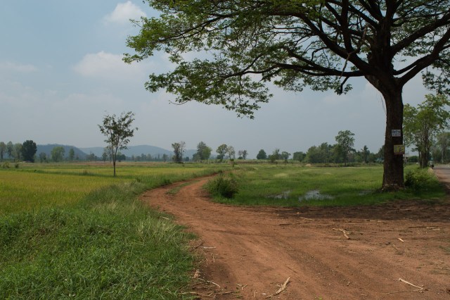
Trying to avoid the main roads has lead to some delightful routes along minor coastal roads and weaving across the plentiful lanes dissecting the numerous and expansive paddy fields; water monitors to the left, water monitors to the right. Occasionally one has scampered ahead of us before taking the plunge.
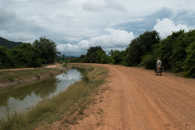
As we progressed south it became more difficult to avoid the ‘principle highways’ full of roaring traffic especially as we were all squeezed between the mountains and around the many inlets and rivers. At one point, two of our three electronic navigation devices said, ‘No’, to a way across the river avoiding a main road but Maps.me clearly showed there is a passage. At lunch we quizzed a local guy who spoke reasonable English but he was not interested in the idea of a river crossing. Nothing on the other side except palm plantations, he said, and was clearly in favour of the main road up and round the inlet.
An inner glow welled up inside me, on the other side is a palm plantation: small lanes, no traffic, trees for cover. It couldn’t be better! But did a ferry exist, as there evidently wasn’t a bridge? We set off with our fingers crossed. 1.5 km wasn’t too far to go to find out. As we rounded the corner onto the waters edge the ramp on the other side was clearly visible. Flapping arms directed us further along the road where we came upon an opening between workshops and boat houses. Initially it didn’t look too promising but tucked in at the edge of this broad, rope-strewn slipway was a rickety jetty with a short, dumpy, roof topped boat with a section cut out of its side – the ferry. In a jiff we’d jiggled the bikes across the random, ill fitting planks of the gang way, through the hole onto the ferry, to the amusement of the folks already on board with their small motorbikes lined up ready to go.
There’s a lot of unhappiness worldwide about the way the rainforests are being cut down and replaced with palm oil plantations. Malaysia is a prime example. The same comments probably apply to the old rubber plantations too, and coconut palms. But although they’re undiverse compared to rainforest, they’re not so bleak. Other plants and trees crowd the edges of tracks and irrigation ditches, we see monitors, monkeys and squirrels. Brahminy kites and crested serpent eagles patrol the treetops, while purple herons and kingfishers line the ditches.
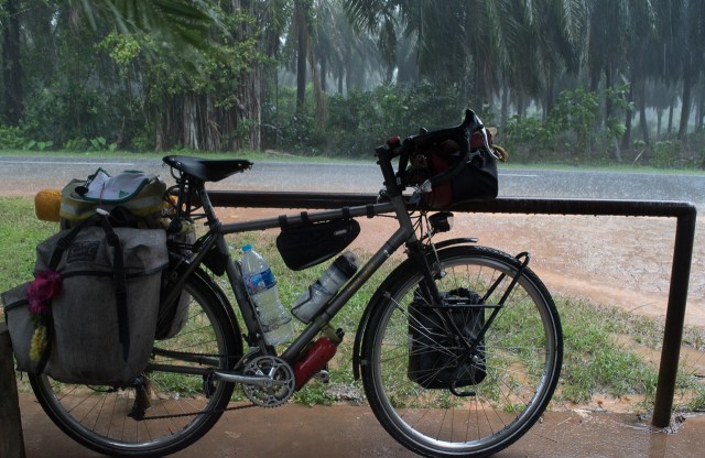
After all our careful planning the South Westerly monsoon has come as a bit of a surprise. Cycling in it has thrown up new challenges. We’ve always attempted to set off early each morning but regularly fail (Gideon sez that’s not a new game, we played it with sea kayaks too). Now there is further motivation. Not infrequently, as the day progresses the black thunder clouds chase us along the roads, the rumbling of thunder close behind, snapping at our heels. The first drops of rain quickly develop into rigid rods beating down upon our backs. Heads low peering forwards as we spy for somewhere to cower; we’ve been remarkably lucky at finding shelter. Mindful of the time however, eventually we have to grit our teeth and set off again. Cars whizz past through newly formed pools and suddenly we’re wearing them. It’s warm of course, but the soggy shorts chafe. Bikes gears and brakes pick up destructive grit and grime.

Our first stop was at Georgetown, a UNESCO listed ex-colonial town on Penang island. Penang was British long before Malaysia’s sultanates fell under the control of the East India Co. or the empire. The island was nominally uninhabited when the sultan offered it, in 1786, to the East India Company in exchange for protection from Siam (which the EIC failed to provide). The EIC brought in a lot of South Indian labour, whose descendants are still running microcosms of India all over the state, and attracted a lot of Chinese, who to this day are the largest ethnic group in Georgetown. It seems quite often in Malaysia that the ethnic mix, and therefore culture, in the cities, is quite different from the country, which is more Malay, and more Islamic.
Whilst I found it fascinating that in such a small area it was possible to find half a dozen architectural styles of shop-houses spanning 300 years it was the clan jetties that captured my imagination most. From cargo landing jetties to the addition of cargo stores to workers shelters to family/clan residences in a little over a hundred years. Built on stilts at the waters edge they cunningly avoid the land tax. Today they sit at the base of immaculate white towering sky scrapers making an awkward mix between old and new. Each clan jetty traces its origins – and the origins of its inhabitants – to a particular province/region in China.
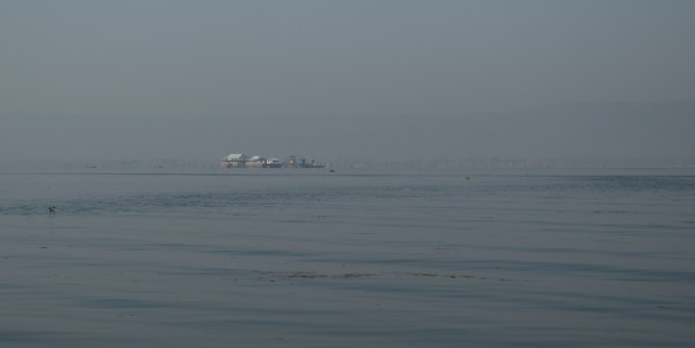
Alas, while on a bus up the coast of Penang, thieves struck, and Gideon’s phone and bank card were stolen. Gideon spent the next couple of hours using Clare’s phone to lock out the old one, change passwords, and call the bank. It was easy enough to replace the phone nearby, and there was little data on it that wasn’t stored online. A new bank card was ordered, which, thankfully, Hailey sent out to our planned Singapore stop. The only ongoing difficulty after a few days was the loss of the UK SIM card, which unfortunately being Vodafone, meant hours and hours of meaningless and useless “customer service” before establishing that probably it couldn’t be replaced without visiting their shops in the UK. The other loss was the really nice phone case I’d made myself – the new phone has to make do with a batik souvenir one, helpfully modified by a little India tailor.
From Georgetown south along the west coast, the Malaysian peninsula is populated and urbanised. The lengthways hills limit the small road options. Little gems like Pontian Kecil, which still encapsulate the Malaysian seafaring and fishing heritage, are few and far between, without unwanted detours. Still, it was our choice, to avoid the hilly Cameron Highlands in the middle, and if we hadn’t wanted to see the cities, the quieter east coast was available. So the cycling latterly has been a bit crap, even though Malaysian drivers are generally slower and more considerate than British ones.
Our second stop in Malaysia was the capital, Kuala Lumpur. With over 7 million souls in its greater area, it is around the 50th biggest city in the world. We’ve increasingly been using Travelfish for city information, as it’s helpfully concise. In this case, it directed us to Chinatown, where we easily found a cheap and comfy hotel. When we strode out in the morning, we stumbled over a good selection of the city’s sights.
British Empire architects seem to have enjoyed themselves with Mughal styles and motifs. These Edwardian low rises are now at the foot of steel and glass towers, many of which, again, refer to Islamic forms. Weaving around the buildings is a modern throng of international people appearing from busy roads, pavements, metro system, monorail. The heat outdoors under the sun is intense, but tall buildings provide shade; shops, malls, hotels and up-market restaurants compete to impress with their sophisticated air conditioning.
Melaka (Malacca) was our final stop in Malaysia. Unlike our other halts, it seemed single-mindedly a tourist town, and little else. Being the weekend it was crowded with tourists from KL and Singapore, pushing the already high prices up a notch or two. A one day dash was sufficient to see yet more notable houses of worship, China town, the Jonker Walk night market and, from multiple other choices, we ventured into the maritime museum. A smaller version of Nelson’s Victory provided the setting for an informative trail through the passage of time in Malaysian sea faring.
Some very pretty cycle rickshaws in Melaka, each with a sound and light show.
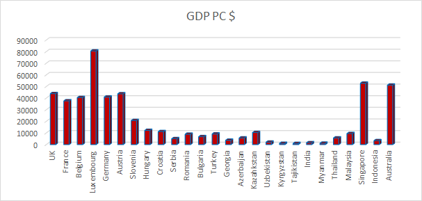
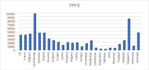
After Malaysia, to the city-state of Singapore, a simple bridge/border crossing, no visa complications, and one of the wealthiest places in the world.
Post dedicated to all our friends at Worthing Camera Club.
The limestone caves near Phetchaburi are lit up with coloured tubes. Beside the cave temples, there’s plenty of interesting drippy rock formations. But how to make a picture of them?
Needs to be a bit more alive, perhaps…
Ok, but only ok. And quite tedious, in a cave, without a tripod or flash gun. Hey, unlike an English cave, tripods aren’t banned 🙂 But I haven’t got one. My camera’s tiny detachable flash is, err, detached. And anyway no help, far too weedy, boringly white, and boringly stuck on top of the camera. So thank you Olympus for making a tiny lens that’s f1.8, that saved those photos. But I still had to get Clare to stand still for way longer than is normal. And can only shoot from an ideally placed stalagmite. And they’re not terribly exciting.
Which got me to remembering some of Worthing Camera Club’s winter lectures a few years back. Intentional Camera Movement is a respectable (ish) discipline that isn’t only “I forgot to bring my tripod to the bluebell wood”. So here are my Thai rocks:
PS: Most of those are colours as shot. A few are rather mucked about with in Lightroom.
Thanks for looking!
Bangkok is stuffed full of temples and historical buildings, as you might expect. Thai Buddhist temples are richly decorated, bright, dripping with gold, and always seem to have a fresh coat of paint. The murals inside are usually worth a study too. All the splendour doesn’t imply overformality of use though. As we’ve seen across the east, temples – including mosques – are places to meet and be, as well as worship. While making phone calls during the service isn’t done, there’s plenty of checking for messages. Perhaps they’re all buying devotional gold leaf on eBay?
Thailand was initially, following on from our route across the ‘Stan’s’, India and Myanmar, extraordinarily ordinary.


A tiny blog posting – a Micropost!
I thought it would be interesting to see how the countries we pass through compare economically. Thanks to Wikipedia, it’s pretty easy.
Here’s a chart showing the Per Capita Income in each country we’ve passed through, or hope to pass through.

And here’s the same chart, adjusted for the cost of living in each country (called Purchasing Power Parity, or PPP).

PPP seems to have the effect of making the people in middle-income states better off. And Singapore.
We can even divide one by the other, to give us a rough Cost of Living Cycling. However, this is a bit rubbish, as in most of Europe, costs were kept down by camping. From about Bulgaria/Romania onwards, it felt a bit insecure rough camping, and hot – we really appreciated the comfort of a shower, so mostly stayed in guesthouses and cheap hotels. In tourist cities, that was often pretty cheap, but out on the road, I would guess that it very often was close to $20/night for a room for the two of us, irrespective of country. So far the most expensive nights have been Uzbekistan ($70 for a yurt), India (~$70 for a tent, ~$40 for a palace (really it was, gorgeous)), and Myanmar ($50 at two of the hotels, trading on scarcity). Not normally regarded as high-cost locations. The Caspian Sea ferry was also an expensive night, but did cover a fair bit of ground as we slept. The Tajikistan Toyota Tour was by far our most expensive week, but wasn’t exactly integral to the trip. And it didn’t include the (cheap) guesthouses!

Turkey, Uzbekistan and India have been most costly for souvenirs, not because of prices, but because of the wonderful handicrafts, and their availability, and perhaps more stop days, and maybe the timing of Christmas.
End of micropost!
After the strenuous riding to get to Inle Lake, before moving on south we studied the map, and profiles, carefully! Thus we decided to turn initially west, to get out of the hills. We had to start by climbing them, but they got even bigger further south. It added about 70km to the route to Kyaikto, our next planned stop, but avoided a lot of climbing. It did, alas, expose us to the apparently regional, afternoon south to north wind, reducing our daily range.
Some of this route was on highway #1, which was a bit busy, but bearable. Main road traffic in Myanmar is mostly largish trucks, with all sorts of cargo. Very few buses, but lots of smallish trucks and pickups crammed with folk and allsorts. A fair bit of agricultural machinery, mostly looking rather improvised. Loads of motorbikes, and a very few cars and bicycles. But even on highway #1, there were enough gaps that drivers usually waited before overtaking, and birdsong could be heard. Other parts were on very quiet country roads, wide or narrow, sometimes dirt but in good condition.
Kyaikto was our rest stop, the nearest town on the highway to the famous Golden Rock. From there it’s 28km to the famous rock and the pagoda atop it. After seeing it we’d then have to backtrack to the main road. An ideal scenario for a rest day and a bus trip. Even more so when the profile showed that the last bit of that 28km ascends nearly a kilometre into the sky. In fact, it seems private vehicles aren’t even allowed on that bit; There are dedicated buses for the pilgrims (and tourists). Actually they’re modified trucks with benches six wide, a roof, and open sides. And pretty powerful engines and brakes, as that road is mighty steep and full of hairpin bends and narrow bits. The truck drivers clearly enjoy the challenge, there was a fair bit of oohing and aaaahhing as the driver hurled the truck round the hairpins, rubber squealing a protest at times.
The rock site was home to many stalls, sub-temples, and hotels. Sitting up on its narrow ridge, it reminded me (Gid) of England’s Lands End complex; but unlike that dour monstrosity, the bright decoration here gleamed in the sun, the colours glowed, the folks were brightly dressed and cheerful. Alas for us, although we deliberately got there approaching photography’s evening “golden hour”, this cast the sun from an unforgiving direction, and we were disappointed by our pictures. It looked like many folk just dossed down there, maybe that’s a better plan for keen photographers.
After Golden Rock, we headed for the Thailand border, between Myawaddy and Mae Sot. I had read about the famous border road that corkscrewed over and through the border mountains, so tight it was only open in one direction each day. About two years ago it was bypassed with a newer, wider, lower, straighter highway – oddly, it’s in OpenStreetMap but not yet in Google Maps. But the day before we met, coming the other way, two English cyclists, Katie and Joseph, who said “you have to go the old road, it’s fabulous..”. The rotters. We decided not to, to spare our legs. Got up early, cycled 2km out of town to where the new road started, looked at the smooth, broad, almost empty, tarmac, sighed, and turned back into town for the old road. Which was, duly, fabulous. We climbed for maybe 2-3 hours. It was indeed narrow, it was indeed very up, although actually reasonably graded (it used to be the main truck route). It had lots of bends, and in a few places was failing to gravel or encroached on by the jungle. We saw about 3 motorbikes, 5 people, and a few houses in the entire way up. There were a few more folk in a village at the top, houses outnumbered by abandoned refreshment shacks from the trucking days.
The way down was only slightly less peaceful (we saw one agri-truck, parked). The road was in good enough shape for a speedy descent.
Although it’s kind of the border road, it’s all inside Myanmar. Reunited with the new road, broad and smooth, we continued to Myawaddy, swapped the last of our Myanmar money, and into the border post. All the terrible internet warnings about Myanmar’s complicated border rules came to naught, and we wiggled through waiting trucks as the 4 lane road squeezed over the 2 lane Friendship Bridge, complicated by changing from right side driving to left side driving over the middle of the river. From there it’s a short flat cruise to the Thai town of Mae Sot, which usually gives its name to this crossing.
This is one of the main crossings between the two countries. It’s really remarkably quiet. I guess this reflects partly the tough terrain, partly Myanmar’s underdevelopment and isolation (although I’m not sure the Thais participated in the sanctions during the long junta years), and maybe also that the history of this border mostly seems to involve sending armies across it, to cause mayhem on the other side. Mostly Burmese, but some Thai, and latterly British and Japanese. And yes, now we’re reading our Indochina history lessons.
Lovely warm smiles. Monks. Slim, smiling, people in longhis or pencil skirts. Myanmar buffet. Stir fried vegetables without chilli. Sane drivers. Elephants. Not much wildlife (guides with catapults!). Hills. Wanting more time.
Inle is a very lovely and scenic shallow lake a few (hard) days cycle south of Tsipaw. It’s one of the tourist “must see” sites in Myanmar. And it’s all conveniently laid out for you. Most of the photos were taken during a day-long trip by long-tail boat, visiting the villages around the lake.

This custom is rapidly dying out, so these middle-aged ladies (sorry!) are likely the last generation to have their collarbones squashed down by the heavy brass coils. It really doesn’t look comfortable, and would make swimming nigh-on impossible.
Yarn made from lotus stems. The cloth ends up coarse and pricier than linen, so not widely adopted elsewhere. Silver smiths, these lads only work when the tourists look their way! The cigar ladies, in contrast, seemed very busy.